По всем вопросам обращайтесь на: info@litportal.ru
(©) 2003-2024.
✖


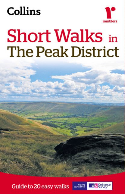
Short walks in the Peak District
Автор
Год написания книги
2019
Настройки чтения
Размер шрифта
Высота строк
Поля
2¼ miles (3.6km) (#litres_trial_promo)
walk 20: Thor’s Cave (#litres_trial_promo)
5 miles (8km) (#litres_trial_promo)
Photo credits (#litres_trial_promo)
Copyright (#litres_trial_promo)
About the Publisher (#litres_trial_promo)
(#litres_trial_promo) (#litres_trial_promo) (#litres_trial_promo) (#litres_trial_promo) (#litres_trial_promo) (#litres_trial_promo) (#litres_trial_promo) (#litres_trial_promo) (#litres_trial_promo) (#litres_trial_promo) (#litres_trial_promo) (#litres_trial_promo) (#litres_trial_promo) (#litres_trial_promo) (#litres_trial_promo) (#litres_trial_promo) (#litres_trial_promo) (#litres_trial_promo) (#litres_trial_promo) (#litres_trial_promo)
walk 1, (#litres_trial_promo)walk 2, (#litres_trial_promo)walk 3, (#litres_trial_promo)walk 4, (#litres_trial_promo)walk 5, (#litres_trial_promo)walk 6, (#litres_trial_promo)walk 7, (#litres_trial_promo)walk 8, (#litres_trial_promo)walk 9, (#litres_trial_promo)walk 10, (#litres_trial_promo)walk 11, (#litres_trial_promo)walk 12, (#litres_trial_promo)walk 13, (#litres_trial_promo)walk 14, (#litres_trial_promo)walk 15, (#litres_trial_promo)walk 16, (#litres_trial_promo)walk 17, (#litres_trial_promo)walk 18, (#litres_trial_promo)walk 19, (#litres_trial_promo)walk 20 (#litres_trial_promo)
Introduction
Walking in the Peak District
When walking in the Peak District you can encounter some quite different types of terrain. Probably the easiest walking of all is on the limestone plateau where stone stiles and green lanes indicate the way. In the dales, paths wander through shady woodland and follow bubbling trout rivers. In the north, the unpredictable weather makes navigation across the trackless moors quite difficult. Gritstone edges above the Derwent, or the lower heather moors, are more straightforward and the footpaths are easier to follow.
Walking is a pastime which can fulfil the needs of everyone. You can adapt it to suit your own preferences and it is one of the healthiest of activities. This guide is for those who just want to walk a few miles. It really doesn’t take long to find yourself in some lovely countryside. All the walks are five miles or less so should easily be completed in under three hours. Walking can be anything from an individual pastime to a family stroll, or maybe a group of friends enjoying the fresh air and open spaces of our countryside. There is no need for walking to be competitive and, to get the most from a walk, it shouldn’t be regarded simply as a means of covering a given distance in the shortest possible time.
What is the Peak District?
The title ‘Peak District’ is something of a misnomer. The name ‘Peak’, in fact, refers to a tribe who lived in the area in ancient times. In the year 924, a cleric writing about the hills and dales of what is now North Derbyshire, referred to the inhabitants as living in ‘Peaclond’ and the name seems to have stuck.
There are really two Peak Districts – Dark and White. The two areas are so completely different that, when standing on the breezy limestone plateau of the White Peak, it is hard to imagine that the untamed wilderness of Bleaklow and Kinder Scout are not far away. Broadly speaking, the Peak District can be sub-divided into six distinct areas;
• The most northerly is the wildest and covers the moors above Saddleworth and the Longdendale Valley with the huge spread of Bleaklow filling the space between Longdendale and the Snake Pass.
• Kinder Scout is a vast boggy plateau bordered to its south by Edale and the graceful sweep of the Mam Tor – Rushup Edge Ridge.
• To the east, rising above the Derwent Valley, there is a long escarpment which is clearly defined by a series of gritstone edges backed by heather moorland.
• In the west, gritstone crags range from The Roaches above Leek to Windgather Rocks and Castle Naze on the northern limits. High open moors offer miles of lesser known walking. Tranquil wooded valleys cutting the western moors are excellent places to walk on hot summer days.
• Limestone makes its most northerly appearance in dramatic cliffs and knolls above Castleton, a place of caves and ancient lead mines. South of Castleton are some of the highest villages in the White Peak. They can expect to be cut off by deep snow for several days during most winters.
• The limestone plateau to the southwest of the A6 is incised by deep valleys and is judged by many to be the prettiest part of the Peak. It is certainly a zone of contrasts where the lush pastures of the rolling uplands have been grazed by cattle since time immemorial. Rivers run pure and clear and they are full of lively trout.
People came early to the Peak. Settling first on the treeless limestone plateau, they left mysterious mounds and stone circles. The circle at Arbor Low between Hartington and Youlgreave was probably the most important. Certainly its surrounding earthworks indicate its significance. Arbor Low is unique as the stones lie flat, unlike the more familiar uprights associated with other circles.
During the Middle Ages, most of the lands were owned by various monasteries. They continued to exploit the lead resources, which was then very much in demand both as a roofing material and for constructing pipes to supply water into a growing number of monastic establishments. The monks opened large tracts of arable grazing and produced wool to clothe an expanding population. Farms which today have the word Grange as part of their name, were owned by rich monasteries until their dissolution by Henry VIII.
Great houses have been built in the Peak. Some are well known, like Chatsworth with its parkland, which was landscaped by Capability Brown, or Haddon Hall – a uniquely preserved medieval country house. There are also many lesser-known stately homes throughout the district which are just as interesting. Most are in private hands, like Tissington Hall which has been owned by the same family for generations. Hartington Hall, a fine example of a Jacobean yeoman’s house is now a youth hostel as is Ham Hall which is an early Victorian mansion preserved by the National Trust.
Visitors to the Peak can buy jewellery made from Blue John, a semi precious stone found only beneath Treak Cliff, near Castleton. Another Peak novelty is the Bakewell Pudding (never call it a tart!). This delicacy was first made accidentally by a 19th century cook working in the Rutland Arms Hotel. Very fine.
Famous writers have penned the virtues of the Peak but none has better links than Izaak Walton (author of ‘The Compleat Angler’ published in 1653), who fished The Dove with the poet Charles Cotton.
Industry has always made its mark. Pack horse, or ‘jaggers’ tracks can still be followed on foot over the northern moors. Saltways crossed the southern dales. Water-powered mills in the early part of the Industrial Revolution brought textile production to the dales. Fluorspar, a nuisance to the early lead miners, is now extracted by open cast mining and used as a flux in steel making and as the basis for a number of chemicals.
Today, without any doubt, it is quarrying which makes the greatest industrial impact on the face of the Peak District. Limestone, suitable either as road aggregates or for cement making, is often only found in scenically attractive areas and, as a result, the quarries can make an ugly scar on the landscape unless they are carefully monitored.
Geology
The rocks which made the foundations of the Peak District were laid down millions of years ago in a warm sea. Miriads of sea creatures living on the slimy bottom built up the great depth of limestone. Tropical lagoons were fringed by coral reefs which, through time, have become the rounded hills of Thorpe Cloud, Parkhouse and Chrome Hills in Dovedale. Minor volcanic activity took place during this time. The best examples of this can be found in the small outcrops of basalt near Castleton and in the dolerite quarry which is part of the Tideswell Dale Nature Trail. Lead found its way in gaseous form, through minute cracks in the underlying rocks, laying down the basis of what became a major industry thousands of centuries later. Copper was also deposited in this way, occurring beneath Ecton Hill in the Manifold valley.
A mighty river delta flooded into the tropical sea, depositing mud and sand which consolidated to make the gritstones of the Dark Peak and the shales of Mam Tor.
Gradually, the layers of limestone and gritstone bulged from pressures deep within the earth and the middle and edges split. Ice action later honed the land into the beginning of the Peak District’s rocky pattern. At the end of the Ice Age, huge volumes of melt water continued this shaping. The water carved caverns within the limestone of Castleton and Matlock as well as the pot holes of Eldon and it also created the beautiful dales. The land tilted as it buckled to give west facing gritstone outcrops on both sides of the Peak.
Wildlife in the Peak District
Grouse spend their hardy lives on the high moors of the Dark Peak feeding on the tender shoots of young heather. Their tough existence is rudely shattered for four months of every year beginning on the ‘Glorious Twelfth of August’. Not so common, and regrettably often shot by mistake, are their cousins the black grouse. Birds of prey have their chosen areas and many migrants, some quite rare, visit quieter sanctuaries on the moors from time to time. Mountain hares are common despite an inability to quickly shed their winter camouflage once the snows have gone. Foxes live a frugal life, mainly dependent upon voles and other small creatures. Plant life on the acid moors has to be tough to combat the extreme weather conditions. Heathers, coarse grass and berry plants such as bilberry, cloudberry and crowberry manage to survive in this harsh environment.
The limestone plateau is much more gentle. It is mainly given over to grazing and masses of colourful flowers still fill the hayfields and road verges. Scabious, meadow cranesbill and other plants, which were once scarce, have made a recent comeback in fields where far-sighted farmers have moved back to natural and cheaper methods of fertilising the land. Plant, and to a certain extent animal life, in the dales depend on the underlying strata. The Upper Derwent and its tributaries flow mostly through shale and gritstone. Forests planted around the Derwent Reservoirs are a major feature and offer homes to woodland birds and a few deer as well as the smaller carnivorous animals. In the limestone dales, trees were once cut down for fuel but they are plentiful today and, in some instances, they are crowding other plant life. In Dovedale, a courageous scheme has removed much of the invasive woodland to recreate more open vistas. Plant life on the craggy scree-covered hillsides is mostly dwarf and with an almost alpine quality. But the dales are best known for their trout streams. Not only do game fish breed in their clear waters, but crayfish, a crustacean which needs pure water, is found beneath the rocks of most of the rivers in the dales.
The Peak District National Park
The Peak District National Park was designated in 1951 and extends over 542 square miles (1404 sq.km). Divided into two uniquely different zones, with wild gritstone moors to the north and gentler limestone uplands and dales to the south, it is surrounded by millions of people living in the industrial areas of England. Due to the advent of motorways the Peak is accessible to the bulk of the population in under two hours. The Peak District was the first National Park and is the most visited.
Administration of the park is controlled by a committee composed, on a proportional basis of representatives of the surrounding County, City, District and Borough Councils as well as members appointed by the Secretary of State for the Environment (Defra).
One of the statutory functions of a Park Authority is the appointment of full-time and voluntary Park Rangers. These are people with particular knowledge of some aspects of the local environment who are available to give help and advice to visitors. Other functions of the Ranger Service include giving assistance to local farmers in such matters as rebuilding damaged walls to prevent stock from straying and leading guided walks from one of the Information Centres. Permanent Information Centres open all year are based at Edale, Castleton, Bakewell and Fairholmes. There are other information centres throughout the National Park.
One of the first tasks the Peak District National Park set itself after its formation in 1951 was to negotiate access agreements. These were not always straightforward but, by careful and diplomatic negotiation, agreements have been reached with farmers and landowners giving free access to most of the high moors of the Dark Peak. Large parts of moorland, including Kinder Scout, are open to unrestricted walking and rock climbing apart from a few days in summer when sections of the moors are closed for grouse shooting. To check moorland closures check with PDNPA, Aldern House, Baslow Road, Bakewell DE45 1AE. Tel: (01629) 816200. email customer.service@peakdistrict.gov.uk (mailto:customer.service@peakdistrict.gov.uk)
The Moorland Centre at Fieldhead, Edale S33 7ZA has an interactive exhibition based on a moorland theme, including Kinder Scout and the Pennine Way. The building is roofed with sedum turf and has an attractive indoor waterfall.
Walking tips & guidance
Safety
As with all other outdoor activities, walking is safe provided a few simple commonsense rules are followed:
• Make sure you are fit enough to complete the walk;
• Always try to let others know where you intend going, especially if you are walking alone;
• Be clothed adequately for the weather and always wear suitable footwear;
• Always allow plenty of time for the walk, especially if it is longer or harder than you have done before;
• Whatever the distance you plan to walk, always allow plenty of daylight hours unless you are absolutely certain of the route;
• If mist or bad weather come on unexpectedly, do not panic but instead try to remember the last certain feature which you have passed (road, farm, wood, etc.). Then work out your route from that point on the map but be sure of your route before continuing;
Другие электронные книги автора Collins Maps


Последний отзыв
Информатика. 4 класс

 3.33
3.33
интересный учебник