Последний отзыв

Удивительная книга. Как никогда актуальна сегодня. Язык и стиль автора настолько тонок, лёгок и изыскан, что легко поведёт читателя в мир героев, кото...
Далее
По всем вопросам обращайтесь на: info@litportal.ru
(©) 2003-2024.
✖


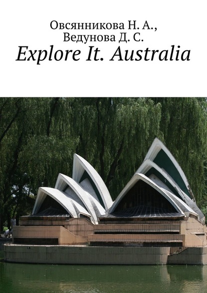
Explore It. Australia
Настройки чтения
Размер шрифта
Высота строк
Поля
Explore It. Australia
Д. С. Ведунова
Н. А. Овсянникова
Данное пособие является продолжением серии Explore It. В нём рассказывается о жизни в Австралии, устройстве этого государства. Пособие предназначено для учащихся общеобразовательных учебных заведений.
Explore It. Australia
Н. А. Овсянникова
Д. С. Ведунова
© Н. А. Овсянникова, 2020
© Д. С. Ведунова, 2020
ISBN 978-5-0051-4256-6
Created with Ridero smart publishing system
Geographical position and peculiarities of the country
Australia ([ə'streɪljə], from Latin austrālis – “southern”), the official form is the Australian Union, or Commonwealth of Australia is a state in the Southern Hemisphere, occupying the continent of the same name, the island of Tasmania and several other islands of the Indian and Pacific oceans. It is the sixth-largest country in the world. East Timor, Indonesia, and Papua New Guinea are located to the north of the Commonwealth of Australia, Vanuatu, New Caledonia, and the Solomon Islands to the northeast, and New Zealand to the southeast.
The mainland of the Commonwealth of Australia is separated from the main island of Papua New Guinea by the Torres Strait with a minimum width of about 150 km, and the distance from the Australian island of Boigu to Papua New Guinea is about 5 kilometers. The population as of 31.12.2018 was estimated at 25,180,200. The majority of population lives in cities on the east coast.
Australia is one of the developed countries, being the thirteenth largest economy in the world, and has the sixth largest GDP per capita in the world. Australia’s military spending is the twelfth largest in the world. With the second highest human development index, Australia ranks high in many areas, such as quality of life, health, education, economic freedom, civil liberties and political rights. Australia is a member of the G20, WTO, APEC, UN as well as of the Commonwealth of Nations and the Pacific Islands Forum.
Geographical position
The Commonwealth of Australia is a state in the Southern Hemisphere with an area of 7,692,024 km². Australia is the sixth largest state in the world after Russia, Canada, China, the USA and Brazil, occupying about 5% of the Earth’s land surface. It includes: mainland Australia (including the island of Tasmania) with an area of 7 659 861 km² and other offshore islands with an area of 32 163 km². Australia controls several outer territories: the Cocos (Keeling) Islands with an area of 14 km², Christmas Island with an area of 135 km², Ashmore and Cartier Islands with an area of 199 km², the Coral Sea Islands with an area of 7 km² (water area about 780 thousand km²), Heard Island and the McDonald Islands with an area of 372 km² (part of the Australian Antarctic Territory), Norfolk Island with an area of 35 km² and the Australian Antarctic Territory with an area of 5 896 000 km² (Australia’s sovereignty over this territory is not recognized by most countries in the world). The total area of all external territories is 5 896 762 km² (without the Antarctic territory – 762 km²).
The northern and eastern coasts of Australia are washed by the seas of the Pacific Ocean: Arafur, Coral, Tasman, Indian Ocean – Timor; western and southern – Indian Ocean. The large islands of New Guinea and Tasmania are located near Australia. The Great Barrier Reef, the world’s largest coral reef, stretches for more than 2000 kilometers along the north-eastern coast of Australia.
Australia stretches from west to east for about4,000 kilometers, and from north to south for almost 3,860 kilometers. The extreme points of the mainland are: in the north – Cape York (10° S), in the south – Cape South East Cape (43° S), in the west – Cape Steep Point (114° E), in the east – Cape Byron (154° E).
The length of Australia’s coastline is 59,736 km (of which the mainland is 35,877 km, the island is 23,859 km), and the area of the exclusive economic zone is 8,148,250 km².
Climate
Australia’s climate is heavily influenced by ocean currents, including the Indian Ocean dipole and El Niño, which create periodic droughts and seasonal tropical low pressures that lead to cyclones in northern Australia. These factors cause a marked change in rainfall from year to year. Most of the country’s north has a tropical climate with predominantly summer rainfall. Nearly three quarters of Australia are deserts and semi-deserts.
In the southwestern part of the country, the climate is Mediterranean. Most of the southeast of the country (including Tasmania) has a temperate climate. The aridity of the region is influenced by the cold West Australian Current, which does not provide energy for the formation of a cyclone. Something similar is happening in the west of South America, but everything changes there with the advent of El Niño.
Geological structure
The country’s territory is based on the ancient Australian Platform, which is part of the Gondwana continent in the southern hemisphere of the Earth.
Relief
Most of the country’s territory is occupied by vast deserts and low-lying areas. The most famous deserts are the Great Sandy Desert, the Great Victoria Desert. To the east of the Victoria Desert lies the Great Artesian Basin semi-desert. In the east of the mainland, there are severely destroyed, low mountains of the Hercynian folding – the Great Dividing Range with a maximum height in the south (Mount Kostsyushko, 2228 m; Townsend, 2209 m). Faults and river valleys dissect mountains into separate massifs.
The tops of the mountains are domed. The eastern slopes of the mountains drop abruptly to the sea, the western ones are gentler. Australia is the only mainland without active volcanoes and modern glaciation.
The lowest point in Australia is Lake Eyre (—15 m), which covers an area of about 15,000 km².
Mount Kostsyushko is the highest point of the Australian continent. The highest point of the country (Mawson Peak volcano) is located on the subantarctic island of Heard.
Natural resources
The main natural wealth of the country is mineral resources. Australia’s natural resource potential is 20 times higher than the world average. The country ranks 2nd in the world in terms of bauxite reserves (1/3 of the world’s reserves and 40% of production), zirconium, 1st in the world in uranium reserves (1/3 of the world’s) and 3rd place for its production: 8022 tons in 2009. The country ranks 6th in the world in terms of coal reserves. It has significant reserves of manganese, gold and diamonds. In the south of the country (Brownlow field), as well as off the north-eastern and north-western coasts in the shelf zone, there are minor deposits of oil and natural gas.
Nature
Although most of the continent is semi-desert and desert, Australia has a variety of landscapes, from similar alpine meadows to tropical jungles. Due to the continent’s significant age (as well as low soil fertility), a wide variety of weather conditions and long-term geographic isolation, Australia’s biota is rich and unique. The flora and fauna of Australia in total include about 12 thousand species, of which about 9 thousand are endemics. Among flowering plants 85% are endemic, among mammals – 84%, birds – 45%, coastal fish – 89%. Many of Australia’s ecological regions and their flora and fauna are threatened by human activities and introduced plant and animal species.
History of Australia
Australia was inhabited about 50,000 years ago, and the remains of its indigenous population are Australian Aborigines. Documented History of Australia begins with its discovery by Europeans in the early 16th century.
The first documented landing of a European on the shores of Australia took place in 1606 – it was the Dutchman Willem Janszon. In addition to him, during the 17th century, another 29 Dutch sailors explored the western and southern coasts of the continent, giving it the name “New Holland”.
The first fleet of British ships landed in Botany Bay in January 1788 and established a prison colony there. In the century that followed, the British established other colonies on the continent, and European explorers penetrated deep into Australia. During this period, the Australian aborigines were seriously weakened by imported diseases and their numbers declined, including during conflicts with the colonists.
By the middle of the 19th century, democratic parliaments were formed in all six British colonies. In 1901, a referendum was held in which the colonies spoke in favour of the formation of a federation. From this moment the history of modern Australia began. Australia fought alongside Britain in both World Wars and has become a long-term ally of the United States since the threat of an invasion by the Japanese Empire in World War II. Trade ties with Asia were strengthened, and the post-war immigration program attracted over 6.5 million migrants from all continents. The post-war influx of migrants from more than 200 countries allowed the population to grow to 23 million people by 2014, and the national economy to become the 12th largest in the world.
Australia was presumably inhabited 40 to 60 thousand years ago. Humans arrived in Australia by sea at a time when New Guinea and Tasmania were part of the continent, making them the earliest maritime travellers in the world. The population of the continent by people began 42—48 thousand years ago.
The oldest human remains on the continent, the so-called Mungo man, are about 40 thousand years old. These remains are one of the oldest examples of cremation found on Earth, indicating the early existence of religious rituals among Australian aborigines. The first inhabitants of Australia were extremely massive and very large people.
The modern anthropological appearance of the Australian aborigines acquired approx. 4 thousand years ago.
Existing estimates of the size of the indigenous population of Australia before colonization, at the end of the 18th century, vary in the range between 315 and 750 thousand people. This population was divided into approximately 250 peoples, many of whom were in alliances with each other. Each nation spoke its own language, and some even several languages, so that there were more than 250 Australian Aboriginal languages. About two hundred of these languages have now become extinct.
Everyday life and material culture of different peoples differed significantly. The highest population density was in the south and east of Australia, in particular in the Murray River Valley.
The first reliable report on the observation of the Australian territory by Europeans dates back to 1606, when the expedition of the Dutchman Willem Janson on the ship “Duifken” explored the Gulf of Carpentaria and landed on the Cape York Peninsula. In 1616, another Dutchman, Derk Hartog, landed at Shark Bay in Western Australia. The coast of Australia was called New Holland and declared the possession of the Netherlands, but the Dutch never mastered it. However, back in 1606, the Spanish expedition of Pedro Fernandez Quiros landed on the New Hebrides and, believing that this is the southern continent, called it the Southern Land of the Holy Spirit. Later that year, Kyros’s deputy, Luis Vaez de Torres, sailed through the Torres Strait and may have seen the northern coast of Australia.
Abel Janszon Tasman, a Dutch navigator, explorer and merchant, received world recognition for his sea voyages in 1642—1644. The first among the famous European explorers reached the shores of New Zealand, Tonga and Fiji. He also discovered Van Diemen’s Land (later named after him Tasmania, the name of the navigator is also the Tasman Sea). The data collected during his expeditions helped prove the fact that Australia is a separate continent. Thanks to him, the west coast of Australia was displayed on the maps. By the early 18th century, the west coast of Australia had been explored and mapped by Dutch, English and French sailors. No attempts were made to populate the territory.
With the exception of Dutch exploration on the west coast, Australia remained unexplored until the maiden voyage of James Cook. In 1769, Lieutenant James Cook, in command of the HMS Endeavor, travelled to Tahiti to see the transit of Venus across the solar disk. Cook also carried out secret Admiralty instructions to search for the Southern Continent. On April 19, 1770, the crew of the ship Endeavor sighted the east coast of Australia, and ten days later landed at Botany Bay. Cook explored the east coast, and then, together with the ship’s naturalist Joseph Banks, reported a favourable situation for the establishment of a colony in Botany Bay. In 1770, the British expedition of James Cook aboard the ship Endeavor explored and mapped the east coast of Australia, landing for the first time on April 29 at Botany Bay.
British colonization
On January 26, 1788, Captain Arthur Phillip founded the settlement of Sydney Cove, which later became the city of Sydney. This event marked the history of the British colony of New South Wales, and Phillip’s Landing Day is celebrated in Australia as a national holiday, Australia Day. The colony included not only Australia but also New Zealand. The settlement of Van Diemen Land, now known as Tasmania, began in 1803; in 1825 it became a separate colony.
Great Britain formally declared its claims to the western part of Australia in 1829. New South Wales was divided and new colonies created: South Australia in 1836, New Zealand in 1840, Victoria in 1851, Queensland in 1859. In 1863, the Northern Territory, previously part of the Province of South Australia, was founded.
In 1829, the Swan River Colony was founded, which became the nucleus of the future state of Western Australia. Western Australia was founded as a free colony, but then, due to severe labour shortages, also began to accept convicts. The dispatch of convicts to Australia began to decline in 1840 and ceased completely by 1868.
Д. С. Ведунова
Н. А. Овсянникова
Данное пособие является продолжением серии Explore It. В нём рассказывается о жизни в Австралии, устройстве этого государства. Пособие предназначено для учащихся общеобразовательных учебных заведений.
Explore It. Australia
Н. А. Овсянникова
Д. С. Ведунова
© Н. А. Овсянникова, 2020
© Д. С. Ведунова, 2020
ISBN 978-5-0051-4256-6
Created with Ridero smart publishing system
Geographical position and peculiarities of the country
Australia ([ə'streɪljə], from Latin austrālis – “southern”), the official form is the Australian Union, or Commonwealth of Australia is a state in the Southern Hemisphere, occupying the continent of the same name, the island of Tasmania and several other islands of the Indian and Pacific oceans. It is the sixth-largest country in the world. East Timor, Indonesia, and Papua New Guinea are located to the north of the Commonwealth of Australia, Vanuatu, New Caledonia, and the Solomon Islands to the northeast, and New Zealand to the southeast.
The mainland of the Commonwealth of Australia is separated from the main island of Papua New Guinea by the Torres Strait with a minimum width of about 150 km, and the distance from the Australian island of Boigu to Papua New Guinea is about 5 kilometers. The population as of 31.12.2018 was estimated at 25,180,200. The majority of population lives in cities on the east coast.
Australia is one of the developed countries, being the thirteenth largest economy in the world, and has the sixth largest GDP per capita in the world. Australia’s military spending is the twelfth largest in the world. With the second highest human development index, Australia ranks high in many areas, such as quality of life, health, education, economic freedom, civil liberties and political rights. Australia is a member of the G20, WTO, APEC, UN as well as of the Commonwealth of Nations and the Pacific Islands Forum.
Geographical position
The Commonwealth of Australia is a state in the Southern Hemisphere with an area of 7,692,024 km². Australia is the sixth largest state in the world after Russia, Canada, China, the USA and Brazil, occupying about 5% of the Earth’s land surface. It includes: mainland Australia (including the island of Tasmania) with an area of 7 659 861 km² and other offshore islands with an area of 32 163 km². Australia controls several outer territories: the Cocos (Keeling) Islands with an area of 14 km², Christmas Island with an area of 135 km², Ashmore and Cartier Islands with an area of 199 km², the Coral Sea Islands with an area of 7 km² (water area about 780 thousand km²), Heard Island and the McDonald Islands with an area of 372 km² (part of the Australian Antarctic Territory), Norfolk Island with an area of 35 km² and the Australian Antarctic Territory with an area of 5 896 000 km² (Australia’s sovereignty over this territory is not recognized by most countries in the world). The total area of all external territories is 5 896 762 km² (without the Antarctic territory – 762 km²).
The northern and eastern coasts of Australia are washed by the seas of the Pacific Ocean: Arafur, Coral, Tasman, Indian Ocean – Timor; western and southern – Indian Ocean. The large islands of New Guinea and Tasmania are located near Australia. The Great Barrier Reef, the world’s largest coral reef, stretches for more than 2000 kilometers along the north-eastern coast of Australia.
Australia stretches from west to east for about4,000 kilometers, and from north to south for almost 3,860 kilometers. The extreme points of the mainland are: in the north – Cape York (10° S), in the south – Cape South East Cape (43° S), in the west – Cape Steep Point (114° E), in the east – Cape Byron (154° E).
The length of Australia’s coastline is 59,736 km (of which the mainland is 35,877 km, the island is 23,859 km), and the area of the exclusive economic zone is 8,148,250 km².
Climate
Australia’s climate is heavily influenced by ocean currents, including the Indian Ocean dipole and El Niño, which create periodic droughts and seasonal tropical low pressures that lead to cyclones in northern Australia. These factors cause a marked change in rainfall from year to year. Most of the country’s north has a tropical climate with predominantly summer rainfall. Nearly three quarters of Australia are deserts and semi-deserts.
In the southwestern part of the country, the climate is Mediterranean. Most of the southeast of the country (including Tasmania) has a temperate climate. The aridity of the region is influenced by the cold West Australian Current, which does not provide energy for the formation of a cyclone. Something similar is happening in the west of South America, but everything changes there with the advent of El Niño.
Geological structure
The country’s territory is based on the ancient Australian Platform, which is part of the Gondwana continent in the southern hemisphere of the Earth.
Relief
Most of the country’s territory is occupied by vast deserts and low-lying areas. The most famous deserts are the Great Sandy Desert, the Great Victoria Desert. To the east of the Victoria Desert lies the Great Artesian Basin semi-desert. In the east of the mainland, there are severely destroyed, low mountains of the Hercynian folding – the Great Dividing Range with a maximum height in the south (Mount Kostsyushko, 2228 m; Townsend, 2209 m). Faults and river valleys dissect mountains into separate massifs.
The tops of the mountains are domed. The eastern slopes of the mountains drop abruptly to the sea, the western ones are gentler. Australia is the only mainland without active volcanoes and modern glaciation.
The lowest point in Australia is Lake Eyre (—15 m), which covers an area of about 15,000 km².
Mount Kostsyushko is the highest point of the Australian continent. The highest point of the country (Mawson Peak volcano) is located on the subantarctic island of Heard.
Natural resources
The main natural wealth of the country is mineral resources. Australia’s natural resource potential is 20 times higher than the world average. The country ranks 2nd in the world in terms of bauxite reserves (1/3 of the world’s reserves and 40% of production), zirconium, 1st in the world in uranium reserves (1/3 of the world’s) and 3rd place for its production: 8022 tons in 2009. The country ranks 6th in the world in terms of coal reserves. It has significant reserves of manganese, gold and diamonds. In the south of the country (Brownlow field), as well as off the north-eastern and north-western coasts in the shelf zone, there are minor deposits of oil and natural gas.
Nature
Although most of the continent is semi-desert and desert, Australia has a variety of landscapes, from similar alpine meadows to tropical jungles. Due to the continent’s significant age (as well as low soil fertility), a wide variety of weather conditions and long-term geographic isolation, Australia’s biota is rich and unique. The flora and fauna of Australia in total include about 12 thousand species, of which about 9 thousand are endemics. Among flowering plants 85% are endemic, among mammals – 84%, birds – 45%, coastal fish – 89%. Many of Australia’s ecological regions and their flora and fauna are threatened by human activities and introduced plant and animal species.
History of Australia
Australia was inhabited about 50,000 years ago, and the remains of its indigenous population are Australian Aborigines. Documented History of Australia begins with its discovery by Europeans in the early 16th century.
The first documented landing of a European on the shores of Australia took place in 1606 – it was the Dutchman Willem Janszon. In addition to him, during the 17th century, another 29 Dutch sailors explored the western and southern coasts of the continent, giving it the name “New Holland”.
The first fleet of British ships landed in Botany Bay in January 1788 and established a prison colony there. In the century that followed, the British established other colonies on the continent, and European explorers penetrated deep into Australia. During this period, the Australian aborigines were seriously weakened by imported diseases and their numbers declined, including during conflicts with the colonists.
By the middle of the 19th century, democratic parliaments were formed in all six British colonies. In 1901, a referendum was held in which the colonies spoke in favour of the formation of a federation. From this moment the history of modern Australia began. Australia fought alongside Britain in both World Wars and has become a long-term ally of the United States since the threat of an invasion by the Japanese Empire in World War II. Trade ties with Asia were strengthened, and the post-war immigration program attracted over 6.5 million migrants from all continents. The post-war influx of migrants from more than 200 countries allowed the population to grow to 23 million people by 2014, and the national economy to become the 12th largest in the world.
Australia was presumably inhabited 40 to 60 thousand years ago. Humans arrived in Australia by sea at a time when New Guinea and Tasmania were part of the continent, making them the earliest maritime travellers in the world. The population of the continent by people began 42—48 thousand years ago.
The oldest human remains on the continent, the so-called Mungo man, are about 40 thousand years old. These remains are one of the oldest examples of cremation found on Earth, indicating the early existence of religious rituals among Australian aborigines. The first inhabitants of Australia were extremely massive and very large people.
The modern anthropological appearance of the Australian aborigines acquired approx. 4 thousand years ago.
Existing estimates of the size of the indigenous population of Australia before colonization, at the end of the 18th century, vary in the range between 315 and 750 thousand people. This population was divided into approximately 250 peoples, many of whom were in alliances with each other. Each nation spoke its own language, and some even several languages, so that there were more than 250 Australian Aboriginal languages. About two hundred of these languages have now become extinct.
Everyday life and material culture of different peoples differed significantly. The highest population density was in the south and east of Australia, in particular in the Murray River Valley.
The first reliable report on the observation of the Australian territory by Europeans dates back to 1606, when the expedition of the Dutchman Willem Janson on the ship “Duifken” explored the Gulf of Carpentaria and landed on the Cape York Peninsula. In 1616, another Dutchman, Derk Hartog, landed at Shark Bay in Western Australia. The coast of Australia was called New Holland and declared the possession of the Netherlands, but the Dutch never mastered it. However, back in 1606, the Spanish expedition of Pedro Fernandez Quiros landed on the New Hebrides and, believing that this is the southern continent, called it the Southern Land of the Holy Spirit. Later that year, Kyros’s deputy, Luis Vaez de Torres, sailed through the Torres Strait and may have seen the northern coast of Australia.
Abel Janszon Tasman, a Dutch navigator, explorer and merchant, received world recognition for his sea voyages in 1642—1644. The first among the famous European explorers reached the shores of New Zealand, Tonga and Fiji. He also discovered Van Diemen’s Land (later named after him Tasmania, the name of the navigator is also the Tasman Sea). The data collected during his expeditions helped prove the fact that Australia is a separate continent. Thanks to him, the west coast of Australia was displayed on the maps. By the early 18th century, the west coast of Australia had been explored and mapped by Dutch, English and French sailors. No attempts were made to populate the territory.
With the exception of Dutch exploration on the west coast, Australia remained unexplored until the maiden voyage of James Cook. In 1769, Lieutenant James Cook, in command of the HMS Endeavor, travelled to Tahiti to see the transit of Venus across the solar disk. Cook also carried out secret Admiralty instructions to search for the Southern Continent. On April 19, 1770, the crew of the ship Endeavor sighted the east coast of Australia, and ten days later landed at Botany Bay. Cook explored the east coast, and then, together with the ship’s naturalist Joseph Banks, reported a favourable situation for the establishment of a colony in Botany Bay. In 1770, the British expedition of James Cook aboard the ship Endeavor explored and mapped the east coast of Australia, landing for the first time on April 29 at Botany Bay.
British colonization
On January 26, 1788, Captain Arthur Phillip founded the settlement of Sydney Cove, which later became the city of Sydney. This event marked the history of the British colony of New South Wales, and Phillip’s Landing Day is celebrated in Australia as a national holiday, Australia Day. The colony included not only Australia but also New Zealand. The settlement of Van Diemen Land, now known as Tasmania, began in 1803; in 1825 it became a separate colony.
Great Britain formally declared its claims to the western part of Australia in 1829. New South Wales was divided and new colonies created: South Australia in 1836, New Zealand in 1840, Victoria in 1851, Queensland in 1859. In 1863, the Northern Territory, previously part of the Province of South Australia, was founded.
In 1829, the Swan River Colony was founded, which became the nucleus of the future state of Western Australia. Western Australia was founded as a free colony, but then, due to severe labour shortages, also began to accept convicts. The dispatch of convicts to Australia began to decline in 1840 and ceased completely by 1868.
Другие электронные книги автора Д. С. Ведунова


Последний отзыв
Удивительная книга. Как никогда актуальна сегодня. Язык и стиль автора настолько тонок, лёгок и изыскан, что легко поведёт читателя в мир героев, кото...
Далее